

Rohr Lake and Mount Rohr hike near Pemberton


Rohr Lake and Mount Rohr Hike near Pemberton
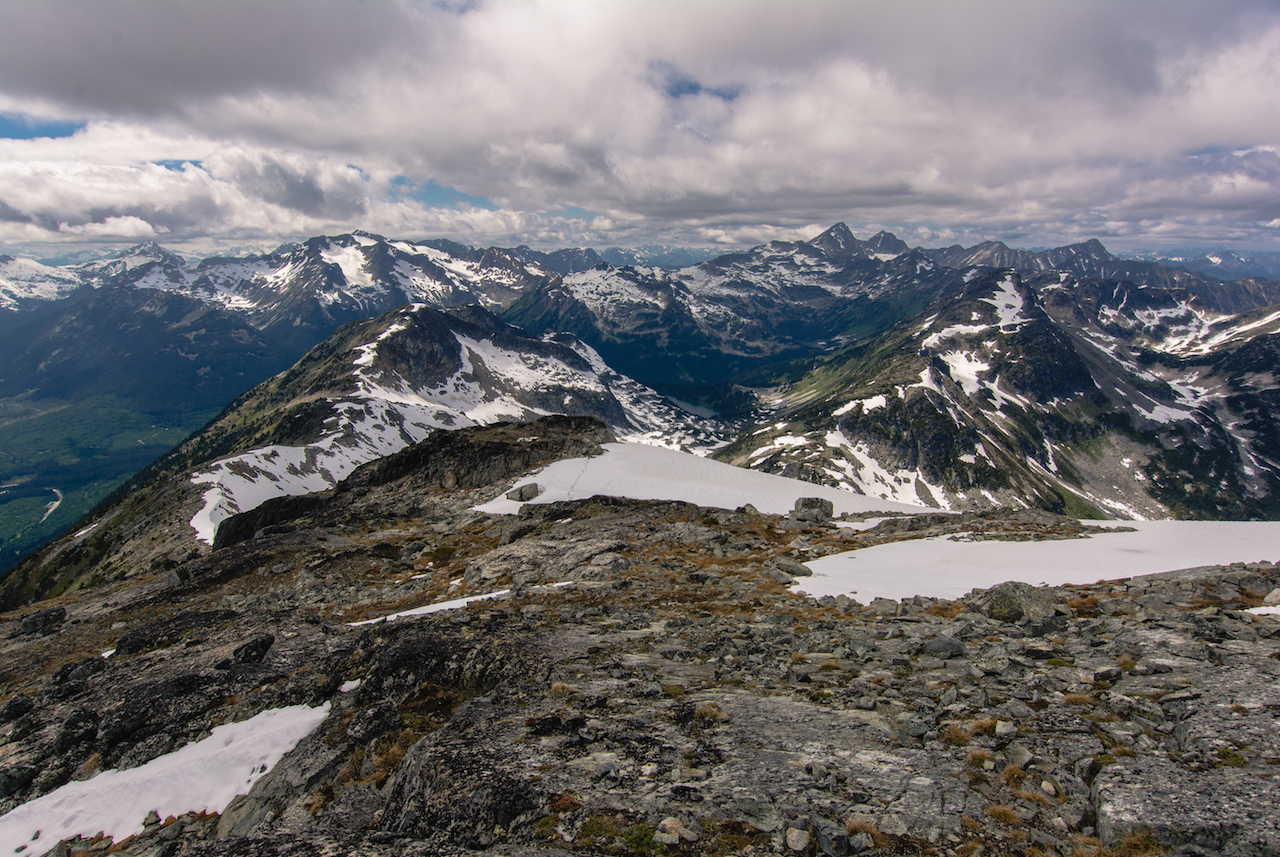
Mount Rohr is a challenging hike that offers incredible scenery, glacial lakes and beautiful alpine terrain. The approximately 8 to 9 hour round-trip hike over 15 km takes you through steep trail and quickly into alpine meadows below long ridge lines. With an elevation gain of 978 m (3,200 ft) and a total elevation of 2,423 m (7,950 ft), this hiking and scrambling paradise is located off of the Duffy Lake Road situated just outside of Pemberton. It’s a beautiful, uncrowded hike offering enough of a challenge for the experienced hiker. Hike, backpack and scramble in the summer; ski tour in the winter. If you love exploring the alpine off trail, this is the place for you!
Distance (Round-Trip): 15 km
Difficulty: Difficult
Season: June to September
Elevation: 2,423 m (7,950 ft) Elevation Gain: 978 m (3,200 ft)
Scenery: ★★★★★
 Camping: Yes
From Vancouver: 3 hrs
Public Transit: No
Dog Friendly: No
The trail begins at the end of an old dirt Forest Service Road (FSR). Parking is found along the side of the road where pullouts are available. To reach the end of the road, a 4x4 vehicle is required as there is some very rough sections of the road. Otherwise, park your vehicle shortly after the fork or wherever logically possible. Keep in mind that depending on your parking location, it may add up to an extra 4km to your hike.
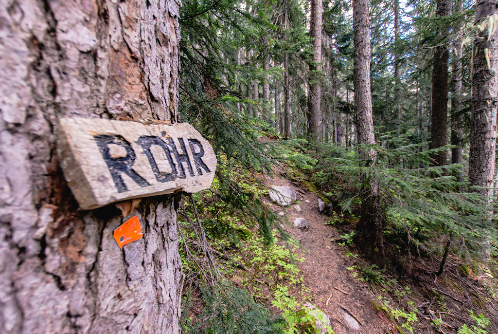
Begin to walk the trail which starts off with numerous muddy sections. The trail will weave its way around trees, over rivers and begin to gain a bit of elevation shortly into the hike. You must take a right once you reach a fork in the trail to access Rohr, otherwise the trail leading left goes to the Wendy Thompson Hut. Carved wooden signs are placed on trees to direct hikers (refer to our pictures for a visual reference).
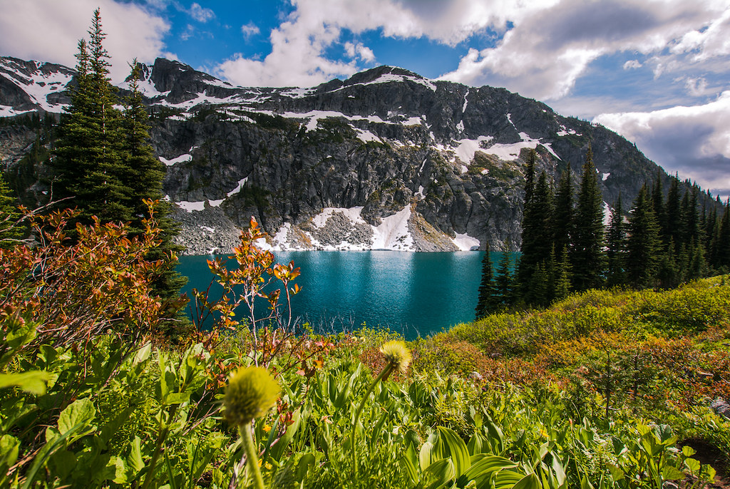
From this point forward, the trail can be very muddy depending on the time of the year, although logs and rocks have been placed to manoeuvre across these sections. You will also encounter many fallen trees along the way. The trail will open up into a meadow and will lead up the right side shortly after. The following section of trail is quite steep and can be hard to follow as you arrive to the ongoing boulder fields. Remain on the right side of the bolder field and choose between the rocks or the muddy side trail to make your way up. At the top of the boulder fields, make your way left across the top to follow the trail. On one of the boulder fields there will be water dripping down the rock face which you must walk along and carefully make your way across into the trees. You will arrive shortly after to Rohr Lake; a beautiful blue lake surrounded by true alpine. This is a great place to camp and/or swim.
Continue your hike left bound along Rohr Lake which will gain a little bit of elevation offering some beautiful viewpoints over the lake. The trail continues through a large meadow and can be hard to follow if snow covered, therefore take your time and look for signs of trail and/or cairns along the way. These cairns will lead you the rest of the way as there is no specific trail. Once at the end of the meadow, you will be facing one mountain on each side and one in the center, the center one is Mount Rohr. Keep in mind that you will encounter numerous false summits before reaching the top.
Begin to ascend slightly left but remaining on the lesser steep incline. Crampons may be required depending on the snow conditions. Beware of possible avalanche hazard and sections where creeks may be running under the snow leaving only a thin layer of snow below your feet. The terrain will eventually plateau at which point you must head left onto the ridge and follow the ridge up and over to the scrambling section. If this part is completely covered in snow, we recommend an ice axe and other safety procedures. Otherwise you will be scrambling up loose rocks. Beware of traffic behind you not to send rocks flying their way and wear a helmet to avoid injuries. If you do send a rock tumbling down towards other hikers, yell “Rock left” or “Rock right” depending which side of them the rock is heading, therefore they can move the opposite direction instantly.
There is only about 100 ft of scrambling to reach the summit. The remainder of the way to the summit slowly begins to flatten out. Continue across the top to the highest point where a pile of rocks has been placed and you will have conquered Mount Rohr standing at 2,423 m (7,950 ft) of elevation.
Pack out all your garbage and leave no trace. Carefully return down the way you came when ready.


CAMPING AT ROHR LAKE AND MOUNT ROHR: YES
You are allowed to camp in the area. Around Rohr Lake is a great spot as well as within the meadow but be sure to reduce your foot print by setting up your tent in already established locations.
 SWIMMING AT ROHR LAKE: YES
Rohr Lake is a perfect location to cool off during hot summer days on your way down from the summit. The lake is glacier fed making it quite cold. Swim at your own risk.
 DOG FRIENDLY AT MOUNT ROHR: NO
Due to the scrambling required to reach the summit, this hike is not suitable for dogs. Although, the trail to Rohr Lake and meadow is dog friendly.
 SKI TOURING AT MOUNT ROHR: YES
During the winter, Mount Rohr is a great ski touring destination.
 PARKING AT ROHR LAKE AND MOUNT ROHR: YES
There are little parking areas for 3-4 cars each scattered gradually along the dirt road. Parking does fill up often and finding parking can be challenging. Keep in mind that depending on your parking location, it may add up to an extra 4km to your hike.